|
Predict
Tides & Currents
and Plan Routes
with Visual GPS Planner!
The
most powerful & popular tidal prediction program in the world now
comes fully integrated with
Nobeltec's Visual Planner..
Tides
& Currents with Visual GPS Planner is a powerful tool that can
instantly predict both tides and tidal currents for thousands of
locations in North America and other parts of the world.
View predictions on top of electronic charts or in an
easy-to-read graphical format. The world’s best-selling and most
powerful tide and current prediction program, Tides & Currents
includes features such as nearest location search, real-time
prediction window, event search, data export, powerful reporting and
printing, sunrise/sunset, moonrise/moonset, and moon phases.
Use
the included Visual GPS Planner software to plan routes, and then
upload or download them between your GPS and PC. Free Passport
planning charts come with the program at no extra charge, and tide and
current predictions go through the year 2100!
Passport
Deluxe charts can be purchased separately for large-scale harbor
detail.
•
Tides
& Currents with US East Coast Data:
$129.99
•
Tides
& Currents with US West Coast Data:
$129.99
•
Tides
& Currents with All US (E & W) Data:
$179.99
| TO
ORDER: |
 |
|
or
call: |
|
1(800)483-8100,
(outside NY Metro),
or 1(516)482-8800 |
|
| |
| Nobeltec
Software Minimum System Requirements |
| • |
Microsoft®
Windows® 98, ME, 2000 or XP |
| • |
Pentium®
III 450 MHz or equivalent |
| • |
128
MB RAM |
| • |
16
MB video card |
| • |
100
MB available had disk space (additional space required for charts
or other data) |
| • |
16
bit color VGA-compatible display (or better) |
| • |
For
VNS & Admiral: Available serial port or USB for GPS connection;
If
you do not have an available serial port, we can supply either a
USB or PCMCIA to serial adapter. |
| • |
Available
USB or parallel port |
| • |
12x
or higher CD-ROM drive |
| • |
Mouse
or other pointing device |
| |
| • |
Recommended:
Microsoft Windows 2000/XP Pro, Pentium III class 1.0 GHz with 256
MB RAM or better, 64 MB (or better) high-end 3D video graphics
card with OpenGL capabilities and a GPS or Loran receiver. |
| |
|
|
|
World
Wide Tidal Data for Tides & Currents
Nobeltec
Tidal Data is the perfect addition to Tides & Currents when you
need more tidal data for locations around the globe. Whether
you are a professional that makes a living around the water, or an
enthusiast setting sail for the next port of call, Nobeltec Tidal
Data provides the additional information you need to navigate
safely.
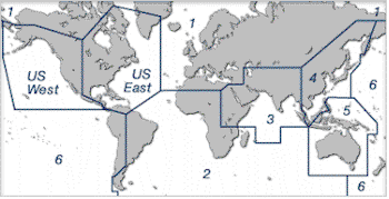
•
US
East or West Coast Data:
$75
•
International
Data per Region:
$55
|
NOBELTEC
CHARTING PRODUCTS COMPARISON TABLE
P = Planner/All Products T
= Tides & Currents
S= Visual Navigation Suite
A = Admiral |
| Features |
P |
T |
S |
A |
|
| |
|
|
|
- ALL
SOFTWARE PRODUCTS FEATURE:
- Geo-Draw
Charting Engine
-Supports Passport Deluxe Regions, World Charts & Bathy Maps, and
all popular raster charts & aerial photos
- Quilting
for seamless charts
- Customizable
Toolbars and Nav Console
- USB
Dongle support
- Route
Trip Tick printing option
- Free US
Planning charts
- Unlimited
routes, marks and waypoints
- 3DNavigator
included
- Free
Weather overlay support
- GPS
upload/download
|
X |
X |
X |
X |
|
- TIDES
& CURRENTS - All the Above Plus:
Includes full copy of Tides & Currents
-Predictions
to 2100; Tide and current overlay on chart; Currents aware ETA
Calculator; Sunrise, sunset, moonphase, & more data; Powerful
tidal reporting
|
|
X |
X |
X |
|
- VNS -
All the Above Plus:
- Course
Up/North Up chart rotation
- Real-time
GPS Navigation
- NavBar
- Autopilot
& external NMEA support
- Twilight
and Night Vision
- Automatic
RouteWizard
|
|
|
X |
X |
|
- ADMIRAL
- All the Above Plus:
- Customizable
vessel sizing
- Track
line coloring w/ incoming NMEA data
- World
Chart Dongle
- NavView
- Vessel
Management Software included
- ARPA and
MARPA Radar support
|
|
|
|
X |
|
|

)
)
)