Or have you come to this page in a frame from another site? Click here to break free
![]()
Or have you come to this page in a frame from another
site? Click here to break free
|
|
||||||||
|
• State-Of-The-Art Electronic Charting • All Of The Most Advanced Features, Yet Easy To Use.
|
||||
|
|||||
| For the boater who wants it all, Nobeltec offers the Visual Navigation Suite. It replaces Nobeltec’s #1 selling NavTrek program and includes all of the features in Nobeltec’s Visual Navigator, GPS Planner and Tides programs. |  |
 |
 |
 |
|
MSRP: |
$489.00 | $269.00 | $99.00 | $99.00 | |
yachtSOFT.com price: |
$429.00 | $239.00 | $89.00 | $89.00 | |
| Depending on your needs, you may wish to start with one of the Suite's component parts. | In one power-packed navigation program you get unrivaled chart handling technology, trip planning, tide and currents reporting (on the chart!), and integration with all of your NMEA 0183 instruments. | Visual Navigator gets you started with official NOAA and CHS charts, full NMEA instrument integration, and world class performance. | Advanced
Trip Planning and GPS Upload/Download. All the power of route planning of Visual
Navigator, for the boater that can't bring along a laptop. Fantastic for easier waypoint/route entry with the new graphic hand-held GPS's. |
One package gives you tide bars and current arrows directly on NOAA charts, as well as familiar graphs. Seamlessly connects BSB or Maptech charts together with GeoDraw and displays current arrows or tide height bars right on the charts! | |
Like to upgrade to
Nobeltec VNS from another charting product; |
|||||
| FEATURES: | • All Visual Series Products Are Ready for Immediate Use with 100 Free NOAA/BSB Planning Charts of US Waters • | ||||
| Accepts Realtime GPS Position |
yes | yes | no | no | |
| Passport Vector Charts | yes | yes | yes | yes | |
| Maptech Raster Charts NOAA BSB & Internt'l Chartpacks |
yes | yes | yes | yes | |
| NDI Canadian Charts | yes | yes | yes | yes | |
| GeoDraw Chart Engine | yes | yes | yes | yes | |
| Printing | yes | yes | yes | yes | |
| Zoom to any scale | yes | yes | yes | yes | |
| Basic Route Planning | yes | yes | yes | yes | |
| Course Up/ North Up | yes | yes | yes | yes | |
| ONF Data Support | yes | yes | yes | no | |
| GPS Upload/Download | yes | no | yes | no | |
| PlanBook | yes | yes | yes | no | |
| Advanced Nav Tools | yes | yes | no | no | |
| Logging | yes | yes | no | no | |
| GPS navigation | yes | yes | no | no | |
| Tides/Currents overlay | yes | no | no | yes | |
| Included Tides & Currents Pro |
yes | no | no | yes | |
| Weather Overlayt | yes | no | no | no | |
| RadarPC Overlay (opt) | yes | no | no | no | |
| Outputs to Autopilot, Radar or other NMEA displays |
yes | no | no | no | |
SOME FEATURES FOUND IN THIS REVOLUTIONARY NEW PRODUCT:
| GeoDraw The GeoDraw chart engine is a huge breakthrough in charting and map viewing technology. GeoDraw enables you to view charts in new ways: |
|
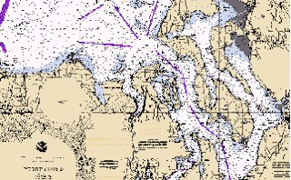
| Chart Rotation: Now charts can be shown in Course Up, North Up and Native Up. | Chart Quilting: Old style raster navigation programs limit you to one chart at a time. Now Nobeltec has eliminated this restriction with GeoDraw . |
| Infinite zooming:
As you zoom out on an old-style charting system, the edges of the chart appear as you
approach them. It's possible to find yourself near the edge of the chart without knowing
what is in front of you. GeoDraw assembles a patchwork of various scaled
charts and "Quilts" them together into a single chart. The Chart boundaries are
barely visible. GeoDraw is able to create this view even from charts with different
projections.
|
Nobeltecs New GeoDraw technology creates a single chart image, made from several charts. |
| The GeoDraw engine chooses the best charts and layers them automatically. You never need to concern yourself with finding a particular chart again. As you zoom in and out, the larger scale charts automatically disappear from view, replaced by smaller scale charts. | These are the NOAA charts that make
this quilted image.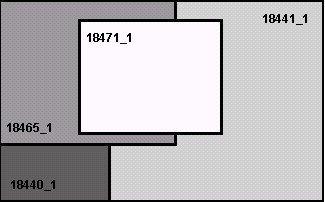 |
| Visual
Tides Tides and currents displayed on electronic charts is one of the most commonly requested features in navigation software. Nobeltec has developed this technology for two breakthrough products, Visual Tides and the Visual Navigation Suite. |
|
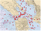
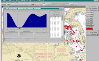 View tide heights and current levels where your boat is located (and where it's headed ! ) . Trip planning has never been so easy, and Nobeltec's Visual series makes it simple to get "the big picture." |
See the image at the top of this page to see how Visual Tides provides an animated view! Tide levels and current flow are instantly visible on a chart, so it's easy to get information about a specific station by simply clicking on it. Tide indicators display a quick indication of tide height while current arrows show current speed and direction at a glance. Change the prediction time by an hour, day, month or an entire year with a simple pushbutton tool! |
| Visual
Navigation Suite or individually Visual Mariner |
TO
ORDER: These products (and
upgrades for Navtrek 97 users) Telephone: 1(800)483-8100 |
| Or e-mail us for the Visual Navigation Suite  by
Nobeltec by
Nobeltec |
yachtSOFT.comtm can bundle complete packages for you, including laptop computer, Nobeltec electronic charting products, and if you like, weatherfax software, GPS, etc., making the transition to marine computing as easy as possible. Please contact us to assemble a system that works for you, and within your budget.
Images and text provided courtesy of Nobeltec; GeoDraw is a trademark of Nobeltec.
©Copyright, All Rights Reserved, yachtSOFT.com LLC, 2001.